Thursday, September 28, 2017
404 error page
ERROR 404
–
NOT FOUND
// You may have mis-typed the URL,
// Or the page has been removed,
// Actually, there is nothing to see here…
404 error page
Sunday, September 24, 2017
GOOGLE MAPS INDIA - ROAD DISTANCE CALCULATOR - INDIA ROAD TRIP
MAP DISTANCE CALCULATOR – Tired of typing the exact location name on maps to get the distance between places? No more hassles now! Just type the origin and destination names below in your own words to get the distance in seconds using the distance calculator!
Distance from major Indian cities to popular destinations (Road distance between cities):
From Delhi
– RAMA ROAD HUB – If you are searching for “Rama Road Hub” then possibly you are looking for either one of the following:
- DHL Rama Road Hub – DHL RAMA ROAD HUB, 13, Najafgarh Rd, Block C, Najafgarh Road Industrial Area, New Delhi, Delhi 110015
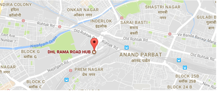
DHL Rama Road Hub
Google India map – DHL Rama Road Hub (long URL) – https://www.google.co.in/maps/place/DHL+RAMA+ROAD+HUB/@28.666186,77.1612733,17z/data=!3m1!4b1!4m5!3m4!1s0x390d0258f07b6a3d:0x6600622f7890bcec!8m2!3d28.666186!4d77.163462
Google India map – DHL Rama Road Hub (short URL) – https://goo.gl/maps/JX9gXGiaeCB2
- Blue Dart Rama Road office – BlueDart, 25, Najafgarh Rd, Block Z, Rajouri Garden Extension, Rajouri Garden, Delhi, 110027

Blue Dart Rama Road
Google India map – Blue Dart Rama Road office (long URL) – https://www.google.co.in/maps/place/BlueDart/@28.6457894,77.0987833,14z/data=!4m5!3m4!1s0x390d036fafaf8ce9:0xc036a8230fd044ef!8m2!3d28.6457894!4d77.1162928
Google India – for Blue Dart Rama Road office (short URL) – https://goo.gl/maps/oyESfZMAfZz
– BAMNOLI SORT CENTRE – If you are searching for “Bamnoli sort centre” then you are possibly looking for one of the below destinations:
- Blue Dart Express Ltd – Bamnoli – BLUE DART EXPRESS LTD- BAMNOLI, 17, Najafgarh Kapashera Road, Sector 28 Dwarka, Dwarka, Delhi, 110061
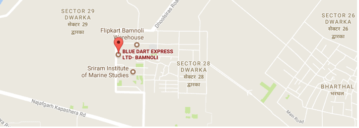
Blue Dart Bamnoli
Google India map – Blue Dart Express Ltd – Bamnoli (long URL) – https://www.google.co.in/maps/place/BLUE+DART+EXPRESS+LTD-+BAMNOLI/@28.5459608,77.018612,15z/data=!4m5!3m4!1s0x390d1a6f33f6a6cf:0xc20857bc554cb96a!8m2!3d28.5459608!4d77.0273667
Google India map – Blue Dart Express Ltd – Bamnoli (short URL) – https://goo.gl/maps/nZ6vXNPE8VK2
- Flipkart Bamnoli Warehouse – Flipkart Bamnoli Warehouse, Plot No. 53/ 54/ 55, Sector 28, Dwarka, Delhi, 110075

Flipkart Bamnoli Warehouse
Google India map – Flipkart Bamnoli Warehouse (long URL) – https://www.google.co.in/maps/place/Flipkart+Bamnoli+Warehouse/@28.5468269,77.0269948,17z/data=!3m1!4b1!4m5!3m4!1s0x390d1a6895e7dff3:0x288e01e8282db6b8!8m2!3d28.5468269!4d77.0291835
Google India map – Flipkart Bamnoli Warehouse (short URL) – https://goo.gl/maps/7bWEyaPJL7E2
- Flipkart Hub, Dwarka (Bamnoli) – Flipkart Hub, Sector 28 Dwarka, Dwarka, Delhi, 110061

Flipkart Hub, Dwarka (Bamnoli)
Google India map – Flipkart Hub, Dwarka (Bamnoli) (long URL) – https://www.google.co.in/maps/place/Flipkart+Hub/@28.5453214,77.0269513,17z/data=!3m1!4b1!4m5!3m4!1s0x390d1a68e09a1e69:0x747289c8f7eb1ac4!8m2!3d28.5453214!4d77.02914
Google India map – Flipkart Hub, Dwarka (Bamnoli) (short URL) – https://goo.gl/maps/7hMB1gbcPBE2
– BAMNOLI – Bamnoli, Sector 28 Dwarka, Dwarka, Delhi, 110061

Bamnoli, Delhi
Google India map – Bamnoli (long URL) – https://www.google.co.in/maps/place/Bamnoli,+Sector+28+Dwarka,+Dwarka,+Delhi,+110061/@28.5453741,77.0308113,17z/data=!3m1!4b1!4m5!3m4!1s0x390d1a684b4c227f:0x2c01dd662498c5e8!8m2!3d28.5447026!4d77.0326981
Google India map – Bamnoli (short URL) – https://goo.gl/maps/ahfRAEFfTsT2
– Delhi to Haridwar distance – 222.2 km /138.06 miles via NH334 (5 hours 26 minutes)
– Delhi to Amritsar distance – 449 km / 278.99 miles via NH44 (6 hours 54 minutes)
– Distance between Delhi to Manali – 536 km / 333 miles via NH 44 (11 hours 35 minutes)
– Nearest metro station to India Gate “is” – Central Secretariat Metro Station, Gate No.1, Red Cross Road, Sansad Marg Area, New Delhi, Delhi 110001
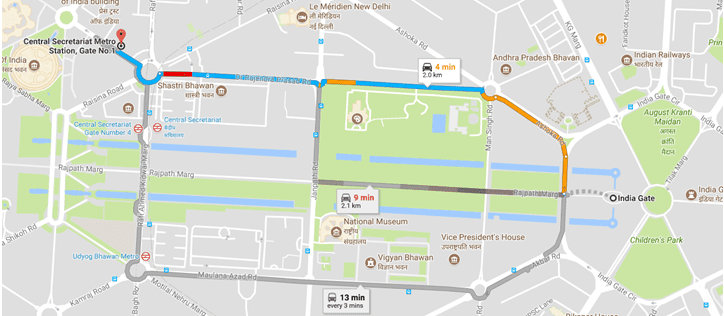
Central Secretariat Metro Station
Google India map – India Gate “to” Central Secretariat Metro Station (long URL) – https://www.google.co.in/maps/dir/India+Gate,+Rajpath+Marg,+New+Delhi,+Delhi/Central+Secretariat+Metro+Station,+Gate+No.1,+Red+Cross+Road,+Sansad+Marg+Area,+New+Delhi,+Delhi/@28.6138986,77.2155781,16z/data=!3m1!4b1!4m13!4m12!1m5!1m1!1s0x390ce2daa9eb4d0b:0x717971125923e5d!2m2!1d77.2295097!2d28.612912!1m5!1m1!1s0x390ce2b3f0be5673:0x49dc6f596b5498a4!2m2!1d77.211335!2d28.617848
– Sarita Vihar metro station – Sarita Vihar Metro Station, Pocket C, Saidabad, New Delhi, Delhi 110076
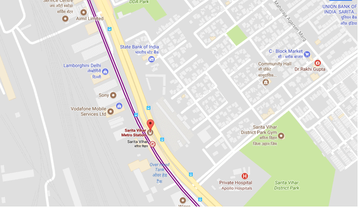
Sarita Vihar metro station
Google India map – Sarita Vihar metro station (long URL) – https://www.google.co.in/maps/place/Sarita+Vihar+Metro+Station/@28.5291095,77.2860023,17z/data=!3m1!4b1!4m5!3m4!1s0x390ce6ad10d36695:0x4dddbb0a9b04f1bc!8m2!3d28.5291048!4d77.288191
Google India map – Sarita Vihar metro station (short URL) – https://goo.gl/maps/PMREF1JjY1x
– Nearest metro station to Nizamuddin railway station “is” – Indraprastha Metro Station, Mahatma Gandhi Road, Indraparshtha, Gas Turbine Power Station, IP Estate, New Delhi, Delhi 110006
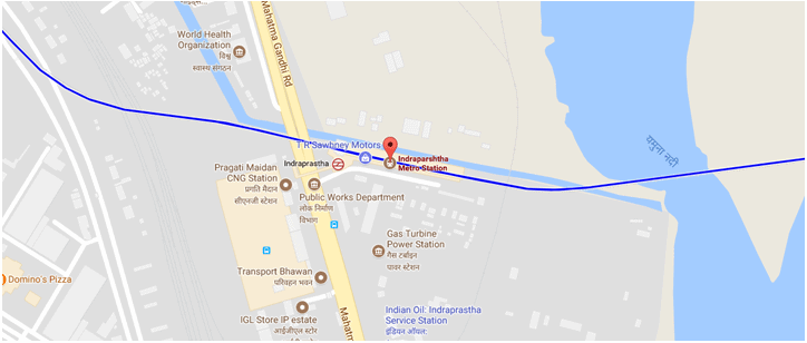
Indraprastha Metro Station, Delhi
Google India map – Indraprastha Metro Station (long URL) – https://www.google.co.in/maps/place/Indraparshtha+Metro+Station/@28.6205327,77.2476893,17z/data=!3m1!4b1!4m5!3m4!1s0x390ce32e804762cf:0x5654e413bb820768!8m2!3d28.620528!4d77.249878
Google India map – Indraprastha Metro Station (long URL) – https://goo.gl/maps/WKVamzJQowo
– Delhi to Goa distance – 1879.1 km / 1167.61 miles via NH48 (33 hours)
Distance from Delhi to Manali 536 km/333 miles via NH 44 (11 hours 35 minutes)
Distance from Delhi to Kasol 517.4 km/321.49 miles via NH 33 (11 hours 10 minutes)
Distance from Delhi to Ladakh 1011 km/628.2 miles via Leh Manali Highway (24 hours)
Distance from Delhi to Mount Abu 764.1 km/474.78 miles via NH48 and Beawar-Pindwara Road (12 hours 54 minutes)
From Mumbai
Distance from Mumbai to Pune 147.7 km/91.77 miles via Mumbai-Pune Highway (2 hours 43 minutes)
Distance from Mumbai to Khandala 81.4 km/50.57 miles via Mumbai-Pune Highway-Pandharpur Road (1 hour 36 minutes)
Distance from Mumbai to Dubai 1934 km/1201.73 miles
Distance from Mumbai to Goa 591.1 km/367.2 miles via NH48 (10 hours 22 minutes)
Distance from Mumbai to Ahmedabad 531.1 km/330.01 miles via NH48 (8 hours 40 minutes)
From Kolkata
Distance from Kolkata to Gangtok 671.2 km/417.06 miles via Badshahi road and NH12 (16 hours 55 minutes)
Distance from Kolkata to Digha 183.3 km/113.89 miles via NH16 and NH116B (4 hours 12 minutes)
Distance from Kolkata to Sikkim 700.6 km/435.33 miles via NH12 (18 hours 15 minutes)
Distance from Kolkata to Bangkok 3344 km/2077.86 miles via Ah Myan Lan (67 hours)
From Chennai
Distance from Chennai to Bangalore 347.2 km/215.74 miles via NH48 (6 hours 39 minutes)
Distance from Chennai to Andaman 1353 km/840.71 miles
Distance from Chennai to Tirupati Balaji 155.5 km/96.62 miles via Tirupati road (3 hours 47 minutes)
Distance from Chennai to Pondicherry 155.2 km/96.43 miles via E Coast road (3 hours 18 minutes)
From Bangalore
Distance from Bangalore to Mysore 150 km/93.2 miles via NH275 (3 hours 9 minutes)
Distance from Bangalore to Tirupati 250.7 km/155.77 miles via NH75 and NH206 (5 hours 6 minutes)
Distance from Bangalore to Coorg 243.5 km/151.3 miles via NH275 (5 hours 15 minutes)
Distance from Bangalore to Pune 837.2 km/520.21 miles via NH48 (13 hours 2 minutes)
Distance from Bangalore to Goa 560.3 km/348.15 miles via NH48 (9 hours 15 minutes)
From Hyderabad
Distance from Hyderabad to Bangalore 575.6/357.66 miles km via NH44 (8 hours 49 minutes)
Distance from Hyderabad airport to Begumpet 36.3 km/22.55 miles via PV Narasimha Rao Express Highway (58 minutes)
From Mysore
Distance from Mysore to Coorg 117.9 km/73.25 miles via Mangalore – Mysore Highway (2 hours 38 minutes)
Distance from Mysore to Ooty 125.6 km/78.04 miles via NH7666 and Mysore-Ooty Road (3 hours 8 minutes)
Distance from Mysore to Kerala 219.5 km/136.39 miles via NH181 (5 hours 51 minutes)
Distance from Mysore to Jog Falls 353.6 km/219.71 miles via Arsikere-Mysore road and NH2016 (7 hours 39 minutes)
From Ahmedabad
Distance from Ahmedabad to Dwarka 441 km/274.02 miles via NH47 and NH947 (7 hours 30 minutes)
Distance from Ahmedabad to Somnath temple 410.8 km/255.25 miles via NH47 (6 hours 59 minutes)
Distance from Ahmedabad to Gir forest 347 km/215.61 miles via NH47 (7 hours 6 minutes)
Distance from Ahmedabad to Mumbai 523.9 km/325.53 miles via NH48 (9 hours 1 minute)
From Earth to …well in…in case you want to travel interstellar
Distance from Earth to Moon 384400 km/238900 miles
Distance from Earth to Sun 149.6 million km/92.96 million miles
Distance from Earth to Mars 54.6 million km/33.9 miles
India Road Trip – Google Maps India:
Note: Click on the map to enlarge and hit the back button in the browser to get back to the post
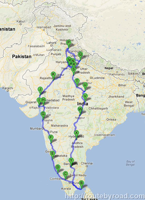
India Road Trip – Google Map – India
Tip: Travel Insurance – Ensure that you get a travel insurance before you start on a long journey. Keep an ID card along with the travel insurance and car insurance documents along with you.
This is an overview and a rough list of the places that I traveled during the India Road Trip:
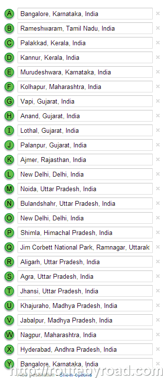
1. Bangalore, Karnataka, India
2. Rameshwaram, Tamil Nadu, India
3. Palakkad, Kerala, India
4. Kannur, Kerala, India
5. Murudeshwara, Karnataka, India
6. Kolhapur, Maharashtra, India
7. Vapi, Gujarat, India
8. Anand, Gujarat, India
9. Lothal, Gujarat, India
10. Palanpur, Gujarat, India
11. Ajmer, Rajasthan, India
12. Pushkar, Rajasthan, India
13. New Delhi, Delhi, India
14. Noida, Uttar Pradesh, India
15. Bulandshahr, Uttar Pradesh, India
16. New Delhi, Delhi, India
17. Shimla, Himachal Pradesh, India
18. Jim Corbett National Park, Ramnagar, Uttarakhand
19. Aligarh, Uttar Pradesh, India
20. Agra, Uttar Pradesh, India
21. Jhansi, Uttar Pradesh India
22. Khajuraho, Madhya Pradesh, India
23. Jabalpur, Madhya Pradesh, India
24. Nagpur, Maharashtra, India
25. Hyderabad, Telangana, India
26. Bangalore, Karnataka, India
Google India Map Snapshot of the places visited during the India Road Trip:
GOOGLE MAPS INDIA - ROAD DISTANCE CALCULATOR - INDIA ROAD TRIP
Tuesday, September 19, 2017
INDIA ROAD TRIP - GOOGLE MAP - INDIA
MAP DISTANCE CALCULATOR – Tired of typing the exact location name on maps to get the distance between places? No more hassles now! Just type the origin and destination names below in your own words to get the distance in seconds!
Note: Click on the map to enlarge and hit the back button in the browser to get back to the post
India Road Trip – Google Map – India
Tip: Travel Insurance – Ensure that you get a travel insurance before you start on a long journey. Keep an ID card along with the travel insurance and car insurance documents along with you.
This is an overview and a rough list of the places that I traveled during the India Road Trip:
1. Bangalore, Karnataka, India
2. Rameshwaram, Tamil Nadu, India
3. Palakkad, Kerala, India
4. Kannur, Kerala, India
5. Murudeshwara, Karnataka, India
6. Kolhapur, Maharashtra, India
7. Vapi, Gujarat, India
8. Anand, Gujarat, India
9. Lothal, Gujarat, India
10. Palanpur, Gujarat, India
11. Ajmer, Rajasthan, India
12. Pushkar, Rajasthan, India
13. New Delhi, Delhi, India
14. Noida, Uttar Pradesh, India
15. Bulandshahr, Uttar Pradesh, India
16. New Delhi, Delhi, India
17. Shimla, Himachal Pradesh, India
18. Jim Corbett National Park, Ramnagar, Uttarakhand
19. Aligarh, Uttar Pradesh, India
20. Agra, Uttar Pradesh, India
21. Jhansi, Uttar Pradesh India
22. Khajuraho, Madhya Pradesh, India
23. Jabalpur, Madhya Pradesh, India
24. Nagpur, Maharashtra, India
25. Hyderabad, Telangana, India
26. Bangalore, Karnataka, India
Google India Map Snapshot of the places visited during the India Road Trip:
INDIA ROAD TRIP - GOOGLE MAP - INDIA
Monday, September 18, 2017
INDIA ROAD TRIP - GOOGLE MAP - INDIA
MAP DISTANCE CALCULATOR – Tired of typing the exact location name on maps to get the distance between places? No more hassles now! Just type the origin and destination names below in your own words to get the distance in seconds!
Note: Click on the map to enlarge and hit the back button in the browser to get back to the post
Tip: Travel Insurance – Ensure that you get a travel insurance before you start on a long journey. Keep an ID card along with the travel insurance and car insurance documents along with you.
This is an overview and a rough list of the places that I traveled during the India Road Trip:
1. Bangalore, Karnataka, India
2. Rameshwaram, Tamil Nadu, India
3. Palakkad, Kerala, India
4. Kannur, Kerala, India
5. Murudeshwara, Karnataka, India
6. Kolhapur, Maharashtra, India
7. Vapi, Gujarat, India
8. Anand, Gujarat, India
9. Lothal, Gujarat, India
10. Palanpur, Gujarat, India
11. Ajmer, Rajasthan, India
12. Pushkar, Rajasthan, India
13. New Delhi, Delhi, India
14. Noida, Uttar Pradesh, India
15. Bulandshahr, Uttar Pradesh, India
16. New Delhi, Delhi, India
17. Shimla, Himachal Pradesh, India
18. Jim Corbett National Park, Ramnagar, Uttarakhand
19. Aligarh, Uttar Pradesh, India
20. Agra, Uttar Pradesh, India
21. Jhansi, Uttar Pradesh India
22. Khajuraho, Madhya Pradesh, India
23. Jabalpur, Madhya Pradesh, India
24. Nagpur, Maharashtra, India
25. Hyderabad, Telangana, India
26. Bangalore, Karnataka, India
Google India Map Snapshot of the places visited during the India Road Trip:
INDIA ROAD TRIP - GOOGLE MAP - INDIA
Temporary Post Used For Theme Detection (87431a82-6928-4eeb-bb2c-0260e5de76db - 3bfe001a-32de-4114-a6b4-4005b770f6d7)
This is a temporary post that was not deleted. Please delete this manually. (250c43d4-ca9d-484c-9961-26c9080c00f6 – 3bfe001a-32de-4114-a6b4-4005b770f6d7)
Temporary Post Used For Theme Detection (87431a82-6928-4eeb-bb2c-0260e5de76db - 3bfe001a-32de-4114-a6b4-4005b770f6d7)
Monday, May 29, 2017
BIHAR TOURISM WITH GLORY OF PAST AND PRESENT
Ancient Nalanda University Bihar
Capital: Patna Largest city: Patna
Bihar is the 13th largest state of India that has 3000 years of glorious history. In other words, the past of Bihar has been the stronghold of its imminence in the whole of India with vibrant economic activities, cultural exchanges, originating place for Buddhism and of conquest and expansion and sites of learning and scholarships. The land has history unlike anything any other states in India has seen. Bihar has abundance of mineral resources.
Introducing Bihar
Bihar is a state in East India and has an area of 94,163 square kilometers and is the 3rd largest populated state of India. The political map of Bihar would show it being bordered by Uttar Pradesh on its west, Nepal at its north, on the east by Northern part of West Bengal and Jharkhand in the south.
Region where Bihar is situated is among the oldest inhabited places by man on the planet and this is primarily due to the River Ganges that flows through it making both sides of its banks very fertile. Apart from that the state is very rich in sources of natural minerals so essential for the development of industries in the whole country.
Bihar has 85% of population living in its numerous villages where subsistence is mainly agriculture. However, of late apart from other industrial development that has staged a comeback; the government of Bihar has laid out greater emphasis on the development of tourist centers in the State both for domestic and foreign travelers.
Notable parts of Bihar’s History
It is quite a common knowledge among archeologists and scholars that in India Bihar was the center of power for learning and culture in the ancient and classical India. Two prominent ruling dynasties and the most powerful India had ever produced on its soil came from Bihar. These were commonly known as the Magadha Empire which was ruled by the Mauryas and the Guptas dynasties. These dynasties together were very successful in keeping within its fold through conquests and co-operation a sizeable part of South Asia under their firm centralized power.
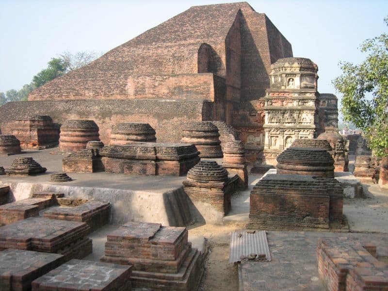
The state capital nowadays known as Patna has a very ancient history and was earlier known as Pataliputra. Near to Patna were the important centers of learning and these were known as Nalanda and Vikramshila. Archeological studies have revealed that these were established in Bihar in the 5th and 8th centuries.
It was here on this land that Buddha got enlightenment and introduced Buddhism to the whole world. In other words, India became a well known mystic land with untold wealth and was soon to be plundered and attacked by foreign invaders which led to the establishment of the Mughal Empire and later under British colonial rulers.
Climate and Geography
Bihar has a subtropical climate in general and yet is notable for its hot summers and cold winters. The banks of the Ganges River keep the temperature of the towns and cities near to it quite hospitable and support one of the largest population bases in the world. You will also see that most ancient monuments and architectures not too far away from the banks of this flowing river.
The Ganges has several tributaries and the most famous of them are Son, Budhi Gandak, Chandan, Orhani and Phalgu. The climate of the state is also greatly affected by the Himalayas although the latter falls in Nepal. You will also find the Rajagiri Hills in Central Bihar although this may affect the climate only mildly. If you proceed further south then you will come across Chota Nagpur Plateau that lies in the new state of Jharkhand.
The climate of Bihar is quite comfortable for average tourists entering the state from other states while for foreigners it would be better to avoid the extreme heat of the summer. Yet there are good affordable and star hotels and the state has good turnover of tourists as it is estimated that around 24 million tourists visit Bihar every year.
For those whom the climate is very important aspect for taking tours then Bihar’s temperature may range between 0 to 10 degrees C in the cold season while during hot season the mercury may sore to 40 degree C.
Tourist Spots of Ancient Wonder
One of the most important tourist center and that can keep you wondering about the learning culture that was predominant of the region’s past is the Nalanda University. This is a must see place as you will be astonished beyond words that this university was in existence in Bihar in India when the whole world had not even thought of a concept called university.
It was well planned structure with an entrance where they used to conduct what one would call an entrance exam and the most distinguished of the pupils would get a chance to enroll for further studies. There were about 2000 teaches who taught around 10000 student from all parts of the world. It is here that Buddha himself taught and the famous Chinese traveler Hein-Tsang was also a student.
If you have visited Nalanda then the next most important place would be the Bodhi Tree where Buddha got his enlightenment. This place is about 100 kilometers from Patna. You may also visit the Maha Bodhi Temple which is also situated quite close to it.
True, a larger part of Bihar tourism revolve around religious as well as learning centers yet for those who knows the ancient and medieval history of this region then this wouldn’t be a surprise. Hence, while visiting religious centers think that these are not simply religious ones, but are part of a greater understanding and revelation of different cultures that was predominantly sculpted out through religious dogmas and practices.
Hence, no tour to Bihar is complete without touring Machalinda Lake and Griddhakuta Peak. The beauty of the Machalinda Lake is that it is named after the serpent called Sesh Naga or the Snake King Machalinda. It is said that Gautama Buddha during his sixth week of meditation was threatened by a storm and it was this Snake King who protected him by providing shelter with its enormous hood. You will find a sculpted form of the Snake King with its hood open and on its coils resting in meditation Lord Buddha himself. The place is more popularly known as Bodh Gaya.
When you reach Griddhakuta Peak then you will be astonished that the whole rocky peak in its natural formation resembles a gigantic vulture. This is quite a marvel by nature itself and even more fantastic scene is that real vultures from the sky and that too in large numbers descend upon the rocks or fly around it.
The Rajgir Hot springs is yet another wonderful spot for tourists and nestles at the foot of the Vaibhava Hills. These hot springs get their water from Saptadhara which flows just behind the Saptaparni Caves. It is said that the hot water in the springs contain medicinal properties that can cure several ailments. Among these hot springs the Brahmakund spring is the hottest and its temperature may reach up to 450 C. It is established that both Buddha and Mahavira frequently bathed in these pools.
You may then visit Buxar Fort which is something quite different from the usual religious monuments. This fort is situated along the Ganga River and offers excellent views of the surrounding landscape. The next must see monument is the Hein-Tsang Memorial Hall which gives you the details about the lifestyles of the people then and the different kinds of cultures, art and crafts.
You may also see the Patna Museum which contains a lot of artifacts and items and also images and sculptor works. You will be amazed to hear that the museum was constructed in 1917.
Not much frequented tourist places
You may find it quite difficult to locate tourist spots that are not quite frequented in Bihar. However, you may visit the wild life sanctuaries which are quite remote and may need special permission from the forest department. These wild areas are great fun if you are touring in groups and have vast numbers of flora and fauna. Some like Bhimbandhu Wildlife Sanctuary is surrounded by thick human populations around its borders.
You may also locate a few good not much known places in Bihar by putting a query with your agents or online websites. In some place it is always better to travel in groups for safety reasons. The Cyclopean Walls which is around 2500 years old and stretches about 40 kilometers long is a mysterious fortification that you may find as something strange.
BIHAR TOURISM WITH GLORY OF PAST AND PRESENT
Subscribe to:
Posts (Atom)