MAP DISTANCE CALCULATOR – Tired of typing the exact location name on maps to get the distance between places? No more hassles now! Just type the origin and destination names below in your own words to get the distance in seconds using the distance calculator!
Distance from major Indian cities to popular destinations (Road distance between cities):
From Delhi
– RAMA ROAD HUB – If you are searching for “Rama Road Hub” then possibly you are looking for either one of the following:
- DHL Rama Road Hub – DHL RAMA ROAD HUB, 13, Najafgarh Rd, Block C, Najafgarh Road Industrial Area, New Delhi, Delhi 110015
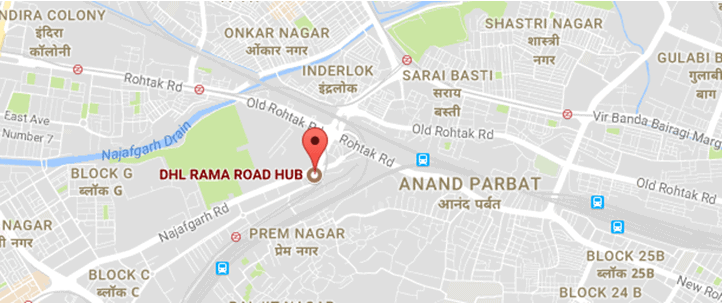
DHL Rama Road Hub
Google India map – DHL Rama Road Hub (long URL) – https://www.google.co.in/maps/place/DHL+RAMA+ROAD+HUB/@28.666186,77.1612733,17z/data=!3m1!4b1!4m5!3m4!1s0x390d0258f07b6a3d:0x6600622f7890bcec!8m2!3d28.666186!4d77.163462
Google India map – DHL Rama Road Hub (short URL) – https://goo.gl/maps/JX9gXGiaeCB2
- Blue Dart Rama Road office – BlueDart, 25, Najafgarh Rd, Block Z, Rajouri Garden Extension, Rajouri Garden, Delhi, 110027

Blue Dart Rama Road
Google India map – Blue Dart Rama Road office (long URL) – https://www.google.co.in/maps/place/BlueDart/@28.6457894,77.0987833,14z/data=!4m5!3m4!1s0x390d036fafaf8ce9:0xc036a8230fd044ef!8m2!3d28.6457894!4d77.1162928
Google India – for Blue Dart Rama Road office (short URL) – https://goo.gl/maps/oyESfZMAfZz
– BAMNOLI SORT CENTRE – If you are searching for “Bamnoli sort centre” then you are possibly looking for one of the below destinations:
- Blue Dart Express Ltd – Bamnoli – BLUE DART EXPRESS LTD- BAMNOLI, 17, Najafgarh Kapashera Road, Sector 28 Dwarka, Dwarka, Delhi, 110061
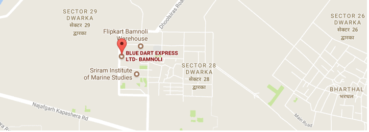
Blue Dart Bamnoli
Google India map – Blue Dart Express Ltd – Bamnoli (long URL) – https://www.google.co.in/maps/place/BLUE+DART+EXPRESS+LTD-+BAMNOLI/@28.5459608,77.018612,15z/data=!4m5!3m4!1s0x390d1a6f33f6a6cf:0xc20857bc554cb96a!8m2!3d28.5459608!4d77.0273667
Google India map – Blue Dart Express Ltd – Bamnoli (short URL) – https://goo.gl/maps/nZ6vXNPE8VK2
- Flipkart Bamnoli Warehouse – Flipkart Bamnoli Warehouse, Plot No. 53/ 54/ 55, Sector 28, Dwarka, Delhi, 110075

Flipkart Bamnoli Warehouse
Google India map – Flipkart Bamnoli Warehouse (long URL) – https://www.google.co.in/maps/place/Flipkart+Bamnoli+Warehouse/@28.5468269,77.0269948,17z/data=!3m1!4b1!4m5!3m4!1s0x390d1a6895e7dff3:0x288e01e8282db6b8!8m2!3d28.5468269!4d77.0291835
Google India map – Flipkart Bamnoli Warehouse (short URL) – https://goo.gl/maps/7bWEyaPJL7E2
- Flipkart Hub, Dwarka (Bamnoli) – Flipkart Hub, Sector 28 Dwarka, Dwarka, Delhi, 110061

Flipkart Hub, Dwarka (Bamnoli)
Google India map – Flipkart Hub, Dwarka (Bamnoli) (long URL) – https://www.google.co.in/maps/place/Flipkart+Hub/@28.5453214,77.0269513,17z/data=!3m1!4b1!4m5!3m4!1s0x390d1a68e09a1e69:0x747289c8f7eb1ac4!8m2!3d28.5453214!4d77.02914
Google India map – Flipkart Hub, Dwarka (Bamnoli) (short URL) – https://goo.gl/maps/7hMB1gbcPBE2
– BAMNOLI – Bamnoli, Sector 28 Dwarka, Dwarka, Delhi, 110061

Bamnoli, Delhi
Google India map – Bamnoli (long URL) – https://www.google.co.in/maps/place/Bamnoli,+Sector+28+Dwarka,+Dwarka,+Delhi,+110061/@28.5453741,77.0308113,17z/data=!3m1!4b1!4m5!3m4!1s0x390d1a684b4c227f:0x2c01dd662498c5e8!8m2!3d28.5447026!4d77.0326981
Google India map – Bamnoli (short URL) – https://goo.gl/maps/ahfRAEFfTsT2
– Delhi to Haridwar distance – 222.2 km /138.06 miles via NH334 (5 hours 26 minutes)
– Delhi to Amritsar distance – 449 km / 278.99 miles via NH44 (6 hours 54 minutes)
– Distance between Delhi to Manali – 536 km / 333 miles via NH 44 (11 hours 35 minutes)
– Nearest metro station to India Gate “is” – Central Secretariat Metro Station, Gate No.1, Red Cross Road, Sansad Marg Area, New Delhi, Delhi 110001
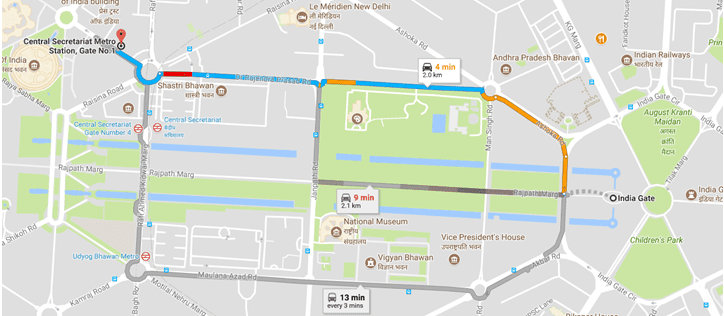
Central Secretariat Metro Station
Google India map – India Gate “to” Central Secretariat Metro Station (long URL) – https://www.google.co.in/maps/dir/India+Gate,+Rajpath+Marg,+New+Delhi,+Delhi/Central+Secretariat+Metro+Station,+Gate+No.1,+Red+Cross+Road,+Sansad+Marg+Area,+New+Delhi,+Delhi/@28.6138986,77.2155781,16z/data=!3m1!4b1!4m13!4m12!1m5!1m1!1s0x390ce2daa9eb4d0b:0x717971125923e5d!2m2!1d77.2295097!2d28.612912!1m5!1m1!1s0x390ce2b3f0be5673:0x49dc6f596b5498a4!2m2!1d77.211335!2d28.617848
– Sarita Vihar metro station – Sarita Vihar Metro Station, Pocket C, Saidabad, New Delhi, Delhi 110076
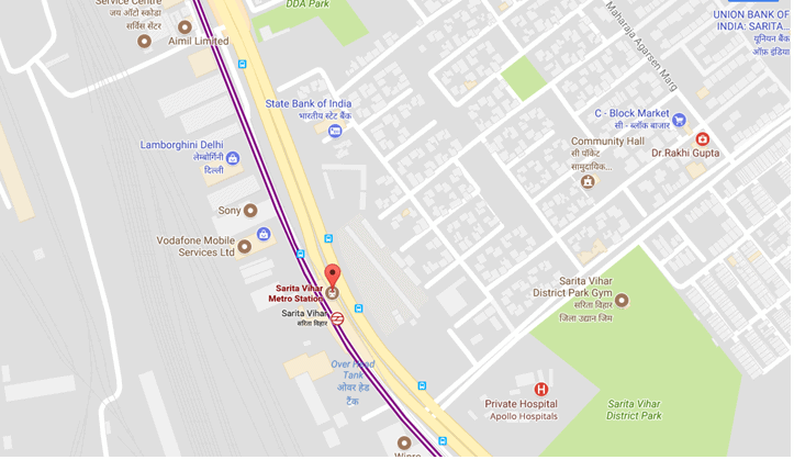
Sarita Vihar metro station
Google India map – Sarita Vihar metro station (long URL) – https://www.google.co.in/maps/place/Sarita+Vihar+Metro+Station/@28.5291095,77.2860023,17z/data=!3m1!4b1!4m5!3m4!1s0x390ce6ad10d36695:0x4dddbb0a9b04f1bc!8m2!3d28.5291048!4d77.288191
Google India map – Sarita Vihar metro station (short URL) – https://goo.gl/maps/PMREF1JjY1x
– Nearest metro station to Nizamuddin railway station “is” – Indraprastha Metro Station, Mahatma Gandhi Road, Indraparshtha, Gas Turbine Power Station, IP Estate, New Delhi, Delhi 110006
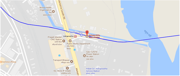
Indraprastha Metro Station, Delhi
Google India map – Indraprastha Metro Station (long URL) – https://www.google.co.in/maps/place/Indraparshtha+Metro+Station/@28.6205327,77.2476893,17z/data=!3m1!4b1!4m5!3m4!1s0x390ce32e804762cf:0x5654e413bb820768!8m2!3d28.620528!4d77.249878
Google India map – Indraprastha Metro Station (long URL) – https://goo.gl/maps/WKVamzJQowo
– Delhi to Goa distance – 1879.1 km / 1167.61 miles via NH48 (33 hours)
Distance from Delhi to Manali 536 km/333 miles via NH 44 (11 hours 35 minutes)
Distance from Delhi to Kasol 517.4 km/321.49 miles via NH 33 (11 hours 10 minutes)
Distance from Delhi to Ladakh 1011 km/628.2 miles via Leh Manali Highway (24 hours)
Distance from Delhi to Mount Abu 764.1 km/474.78 miles via NH48 and Beawar-Pindwara Road (12 hours 54 minutes)
From Mumbai
Distance from Mumbai to Pune 147.7 km/91.77 miles via Mumbai-Pune Highway (2 hours 43 minutes)
Distance from Mumbai to Khandala 81.4 km/50.57 miles via Mumbai-Pune Highway-Pandharpur Road (1 hour 36 minutes)
Distance from Mumbai to Dubai 1934 km/1201.73 miles
Distance from Mumbai to Goa 591.1 km/367.2 miles via NH48 (10 hours 22 minutes)
Distance from Mumbai to Ahmedabad 531.1 km/330.01 miles via NH48 (8 hours 40 minutes)
From Kolkata
Distance from Kolkata to Gangtok 671.2 km/417.06 miles via Badshahi road and NH12 (16 hours 55 minutes)
Distance from Kolkata to Digha 183.3 km/113.89 miles via NH16 and NH116B (4 hours 12 minutes)
Distance from Kolkata to Sikkim 700.6 km/435.33 miles via NH12 (18 hours 15 minutes)
Distance from Kolkata to Bangkok 3344 km/2077.86 miles via Ah Myan Lan (67 hours)
From Chennai
Distance from Chennai to Bangalore 347.2 km/215.74 miles via NH48 (6 hours 39 minutes)
Distance from Chennai to Andaman 1353 km/840.71 miles
Distance from Chennai to Tirupati Balaji 155.5 km/96.62 miles via Tirupati road (3 hours 47 minutes)
Distance from Chennai to Pondicherry 155.2 km/96.43 miles via E Coast road (3 hours 18 minutes)
From Bangalore
Distance from Bangalore to Mysore 150 km/93.2 miles via NH275 (3 hours 9 minutes)
Distance from Bangalore to Tirupati 250.7 km/155.77 miles via NH75 and NH206 (5 hours 6 minutes)
Distance from Bangalore to Coorg 243.5 km/151.3 miles via NH275 (5 hours 15 minutes)
Distance from Bangalore to Pune 837.2 km/520.21 miles via NH48 (13 hours 2 minutes)
Distance from Bangalore to Goa 560.3 km/348.15 miles via NH48 (9 hours 15 minutes)
From Hyderabad
Distance from Hyderabad to Bangalore 575.6/357.66 miles km via NH44 (8 hours 49 minutes)
Distance from Hyderabad airport to Begumpet 36.3 km/22.55 miles via PV Narasimha Rao Express Highway (58 minutes)
From Mysore
Distance from Mysore to Coorg 117.9 km/73.25 miles via Mangalore – Mysore Highway (2 hours 38 minutes)
Distance from Mysore to Ooty 125.6 km/78.04 miles via NH7666 and Mysore-Ooty Road (3 hours 8 minutes)
Distance from Mysore to Kerala 219.5 km/136.39 miles via NH181 (5 hours 51 minutes)
Distance from Mysore to Jog Falls 353.6 km/219.71 miles via Arsikere-Mysore road and NH2016 (7 hours 39 minutes)
From Ahmedabad
Distance from Ahmedabad to Dwarka 441 km/274.02 miles via NH47 and NH947 (7 hours 30 minutes)
Distance from Ahmedabad to Somnath temple 410.8 km/255.25 miles via NH47 (6 hours 59 minutes)
Distance from Ahmedabad to Gir forest 347 km/215.61 miles via NH47 (7 hours 6 minutes)
Distance from Ahmedabad to Mumbai 523.9 km/325.53 miles via NH48 (9 hours 1 minute)
From Earth to …well in…in case you want to travel interstellar
Distance from Earth to Moon 384400 km/238900 miles
Distance from Earth to Sun 149.6 million km/92.96 million miles
Distance from Earth to Mars 54.6 million km/33.9 miles
India Road Trip – Google Maps India:
Note: Click on the map to enlarge and hit the back button in the browser to get back to the post
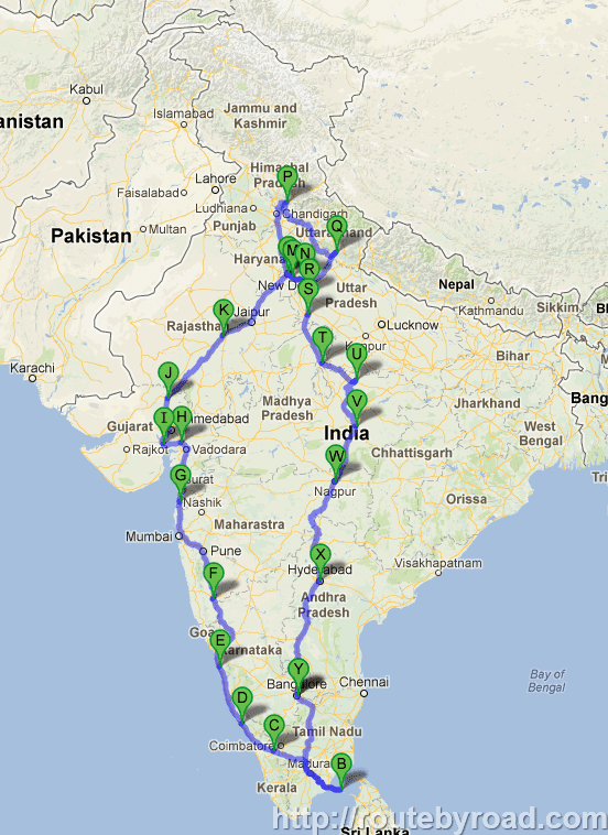
India Road Trip – Google Map – India
Tip: Travel Insurance – Ensure that you get a travel insurance before you start on a long journey. Keep an ID card along with the travel insurance and car insurance documents along with you.
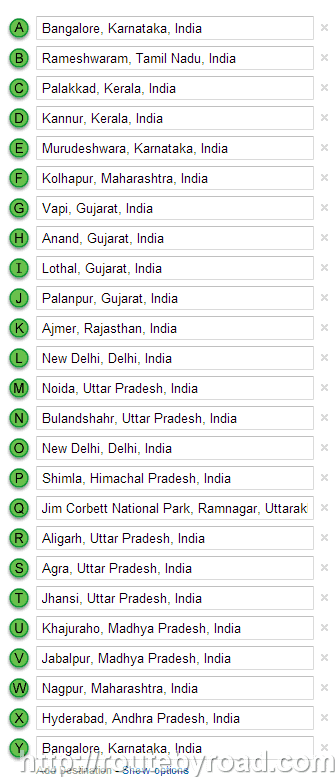
This is an overview and a rough list of the places that I traveled during the India Road Trip:
1. Bangalore, Karnataka, India
2. Rameshwaram, Tamil Nadu, India
3. Palakkad, Kerala, India
4. Kannur, Kerala, India
5. Murudeshwara, Karnataka, India
6. Kolhapur, Maharashtra, India
7. Vapi, Gujarat, India
8. Anand, Gujarat, India
9. Lothal, Gujarat, India
10. Palanpur, Gujarat, India
11. Ajmer, Rajasthan, India
12. Pushkar, Rajasthan, India
13. New Delhi, Delhi, India
14. Noida, Uttar Pradesh, India
15. Bulandshahr, Uttar Pradesh, India
16. New Delhi, Delhi, India
17. Shimla, Himachal Pradesh, India
18. Jim Corbett National Park, Ramnagar, Uttarakhand
19. Aligarh, Uttar Pradesh, India
20. Agra, Uttar Pradesh, India
21. Jhansi, Uttar Pradesh India
22. Khajuraho, Madhya Pradesh, India
23. Jabalpur, Madhya Pradesh, India
24. Nagpur, Maharashtra, India
25. Hyderabad, Telangana, India
26. Bangalore, Karnataka, India
Google India Map Snapshot of the places visited during the India Road Trip:
GOOGLE MAPS INDIA - ROAD DISTANCE CALCULATOR - INDIA ROAD TRIP
No comments:
Post a Comment